We’re halfway there

Since May 16, 2021 the Chicago Transit Authority has been rebuilding the North Side Main Line between Wilson and Thorndale. The project involves replacing a century-old embankment with a more modern concrete elevated structure. Since it’s a four-track line, they are able to keep running trains on the line by rebuilding two tracks at a time and keeping the other two in service. For the past two years the two eastern tracks were being rebuilt while the two western tracks were still in use. Last Friday, on July 28, 2023 at 10pm, the two rebuilt eastern tracks on the new structure entered service.

Back in 2021 when they opened the first round of temporary stations, I was one of the first people to board at the temporary stations (according to the station attendant, I was the second person to board at the temporary Bryn Mawr station). I also was the last passenger to board at Berwyn.

Last northbound train at the old Berwyn station
Last northbound train at Berwyn
Temporary southbound platform at Bryn Mawr looking north, immediately after opening
First temporary Bryn Mawr station

Fast forward to last Friday, it was time for the next round of temporary stations. I arrived at Wilson on the second to last northbound train on the western tracks. The train was delayed about 10 minutes due to needing to remove an unruly passenger, but in the end the issue was resolved and everything continued according to plan. I then was able to catch the first train to use the new tracks:

First northbound train on Track 4 for RPM Phase 1B at Wilson
First train to run on the new tracks!

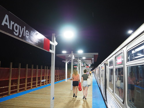
I took that train all the way to Thorndale, catching a picture of the temporary Argyle station through the open door while stopped:

Phase 1B temporary Argyle station from the first northbound train
Argyle station from a northbound train

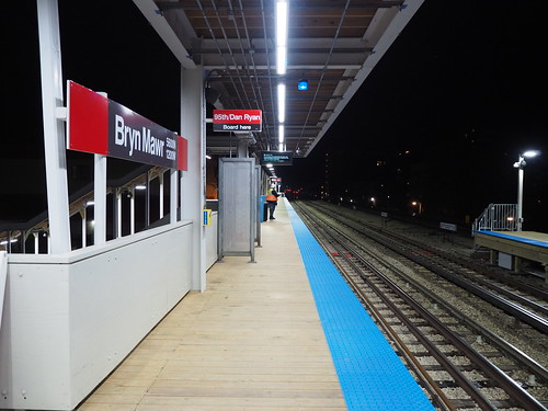
I then continued up to Thorndale, where I was lucky to catch a southbound train right there. I took that one stop south to Bryn Mawr and got off there, where it still stopped at the old temporary station:

Penultimate southbound train at Phase 1B temporary Bryn Mawr station
Second to last train to operate at the first temporary Bryn Mawr southbound station

I got off there and walked over to the new temporary station (which is southbound-only). I also snapped a picture of the original station (which was temporarily serving as the northbound-only platform):

Entrance at the old Bryn Mawr station at closing time
Original Bryn Mawr station, temporary serving as the northbound-only platform

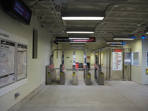
I continued on to the new temporary station, which will be southbound-only. The construction crew asked me to wait until they could confirm that they had rerouted southbound trains via the new tracks. While waiting, I got a few pictures of the entrance:

Fare mezzanine at Phase 1B Bryn Mawr immediately prior to accepting the first passenger
Fare mezzanine at the second temporary Bryn Mawr station
Phase 1B temporary Bryn Mawr entrance on opening night
Entrance at the second temporary Bryn Mawr station

Eventually they confirmed I could enter, and I was the first passenger to board at that station.

Platform at Bryn Mawr, looking south on Phase 1B opening night
Platform at the second temporary Bryn Mawr station

It turned out one more southbound train was rerouted via the old tracks, but then after that the first southbound train arrived.

First southbound train at Phase 1B temporary Bryn Mawr station
First southbound train (and first train) at the second temporary Bryn Mawr station

I took it one stop to Argyle and got off there:

Northbound track at Phase 1B Argyle temporary station, looking north
Second temporary Argyle station

The current temporary Argyle station is an interesting configuration. For one thing, it’s not actually on Argyle street, it’s a block north between Foster and Winona. Also the track configuration is very interesting. They are building a pocket track north of Argyle for turning trains around before reaching Howard, and so far they have built the two mainline tracks and the pocket track. The platform is actually built on top of one of the mainline tracks, with southbound train stopping on the pocket track. This means southbound trains need to go over a crossover both north and south of the station.

I also snapped some photos of the entrances:

Northern Argyle Phase 1B temporary station entrance on opening night
Northern entrance (on Foster)
Southern Argyle Phase 1B temporary station entrance on opening night
Southern entrance (on Winona)

Even for CTA, these were pretty subdued entrances, but that’s to be expected for a station that will only be around for two years.

After photographing Argyle, I caught the next train home.

Overall I am very excited to see this all come together. The new tracks were much smoother than the original tracks and the structure looks way better. Now over the next two years they are going to do the same work to the two western tracks and also build new stations at Lawrence, Argyle, Berwyn, and Bryn Mawr. We are reinvesting in our system and bringing it into the 21st century.

I should also mention I got unbelievably lucky with the weather. The whole time I was there, there was lightning all around, but somehow the rain held off until right after I got home.

Photographing all of Metra… without a car

I am about halfway through photographing all of the stations on Metra right now. According to Wikipedia, there are 242 stations in the system, with two additional ones under construction. According to Flickr, I have photographed 120 of them so far (as of the time I write this there are three stations where I have the photos but haven’t uploaded them). My definition of a station may slightly differ from Wikipedia’s (for example I am counting Prairie Crossing on the North Central Service and Milwaukee District west as a single station), but regardless this puts me at about halfway done.

It certainly has been an adventure trying to photograph all of these stations when I don’t have a car. I was able to photograph the entire L system in about 2.5 years (and most of it was in 1.5 years after I moved here), but Metra is going to take a lot longer. For the L, the stops are mostly relatively close together, all lines run every day, and the frequencies are pretty good. Thus I was usually able to knock out 5-10 stations in a single expedition, using a combination of walking and trains between stations. However Metra isn’t so easy. For one thing, three lines don’t even run on weekends at all (I work a standard Monday-Friday schedule), so for those lines I’m limited to going during the week or finding alternate means to get to the stations. Then for the lines that do run on weekends, they run pretty sparse schedules, once an hour at best. Making things harder, way out in the suburbs the stations are often several miles apart and in many cases there isn’t any sidewalk or pedestrian path to take between them, limiting my ability to walk between them.

Despite these challenges, I have been able to get the photos I have so far. I was lucky enough that last summer, the Heritage Corridor offered promotional Saturday service, allowing me to photograph all but one of the stations on there (and the remaining one appears to be walkable from Joliet on the Rock Island District). I was also able to get a ride with a friend to photograph all of the stations on the SouthWest Service. The North Central Service will be more of a challenge, with so far only Antioch photographed (I took a day off work originally for another purpose but that ended up being cancelled, but since I still had the day off I took advantage of it being a sunny day).

For the other lines, I have used a combination of taking the train and walking long distances between stations where possible. For example there is a pedestrian trail between Ingleside and Fox Lake, allowing me to get those stations in one go. Also a lot of the stations closer to the city are in areas that do have sidewalks, allowing me to walk between them more easily (though it can still be a long walk).

Here are the tallies for each line, not counting the downtown terminus for each:

  • BNSF: 8 out of 25 (32%)
  • Heritage Corridor: 5 out of 6 (83%)
  • Metra Electric: 33 out of 48 (69%, including all stations within the Chicago city limits and on the South Chicago and Blue Island branches)
  • Milwaukee District/North: 6 out of 21 (29%)
  • Milwaukee District/West: 6 out of 21 (29%)
  • North Central Service: 2 out of 17 (12%)
  • Rock Island District: 15 out of 25 (60%, including all stations on the Beverly Branch)
  • SouthWest Service: 12 out of 12 (100%)
  • Union Pacific/North: 16 out of 26 (62%)
  • Union Pacific/West: 9 out of 22 (41%)
  • Union Pacific/West: 7 out of 18 (39%)

I have a lot more work to do for sure, but I’m getting there. I’ve got one line fully complete, only one station left on the Heritage Corridor, and four lines above halfway done. I also have photographed all of the stations on the South Shore Line, but will need to go back out there once Double Track is done to photograph the newer stations, and also once West Lake opens. Some of the stations are in Chicago city limits or inner suburbs and will allow me to walk between them, but some will require a combination of taking trains and walking. I’m not sure how I’ll get the stations on the North Central Service, but I’m sure I’ll make it work.

Here are a few photos I’ve gotten so far:

Outbound platform at Elgin - National Street, looking north
Elgin – National Street
Outbound platform at Hanover Park, looking west
Hanover Park
Platform at Fox Lake, looking west
Fox Lake
Southbound local track at Museum Campus/11th Street Station
11th Street/Museum Campus
Inbound platform at 107th Street - Beverly Hills, looking north
107th Street – Beverly Hills
Inbound Northwest Line platform at Clybourn
Clybourn
Platform at Manhattan, looking north
Manhattan
Platform at McCormick Place, looking north
McCormick Place
Tracks at Wheaton, looking west
Wheaton
Inbound platform at Summit, looking northeast
Summit